Terrain has always been one of the decisive factors in military operations in mountainous environments. Ridges, valleys, steep slopes, ravines and rapid changes in elevation directly affect mobility, observation, lines of sight, protection and, ultimately, the ability of forces to manoeuvre.
Understanding terrain, therefore, means more than reading a map. It requires the ability to visualise the operational environment in its full three-dimensional complexity.
Extended Reality (XR) technologies, encompassing Virtual Reality (VR) and Augmented Reality (AR) applications, are opening new possibilities in this field.
From Maps to Three-Dimensional Terrain
In June 2025, during the NATO Mountain Warfare Operations Planning Course conducted by the NATO Mountain Warfare Centre of Excellence (MW COE) in Poljče, Slovenia, participants had the opportunity to explore emerging technological solutions for military planning.
Held from 9 to 13 June and bringing together officers from eight NATO Allied and Partner countries, the course focused on applying the systematic military planning process to mountainous terrain, with particular emphasis on innovation, Multi-Domain Integration and advanced digital planning tools.
This environment also provided an opportunity to engage with technologies developed by Laabmayr ZT GmbH, an Austrian company involved in the development of three-dimensional and XR solutions for the visualisation of complex environments.
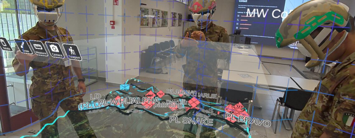
During a dedicated demonstration of their product XR COMMAND, a digital representation of mountainous terrain could be viewed through an XR Headset as a three-dimensional model. Instead of interpreting contour lines and symbols on a flat surface, users could directly perceive mountains, ridges, slopes and valleys, change their perspective and interact with the model through hand-based gestures.
The map, in other words, became space.
Supporting Military Decision-Making
XR environments do not replace the military planning process or the professional judgement of commanders and staff officers. They can, however, provide an additional means of enhancing situational understanding and decision support.
Terrain, routes, friendly and adversary positions and other mission-relevant information can be represented within the same three-dimensional environment. Different Courses of Action can therefore be visualised, discussed and compared against a common representation of the Area of Operations.
An additional advantage is the collaborative dimension of XR environments. Multiple users can simultaneously view and interact with the same virtual representation of the terrain while operating within a shared physical space. Commanders and staff officers can therefore examine the same virtual map together, discuss routes, positions, threats and potential Courses of Action, and develop a shared understanding of the operational environment. Rather than interpreting separate individual representations, participants can work directly on a common three-dimensional operational picture.
This becomes particularly relevant in Mountain Warfare.
On relatively flat terrain, a two-dimensional representation may provide a reasonably intuitive understanding of spatial relationships. In the mountains, however, the vertical dimension fundamentally alters those relationships. Two locations that appear close together on a map may be separated by a ridge, a significant elevation difference or an obstacle that severely restricts movement. Likewise, relatively small differences in elevation may determine whether a force can observe an adversary position – or remain concealed from it.
The third dimension is therefore not merely a graphical enhancement of the map. In mountain warfare, it is an integral part of the operational problem.
Seeing the Terrain from the Adversary's Perspective
The operational potential of this technology extends considerably beyond the visual impact of a three-dimensional terrain model.
Tactical information and symbols can be integrated into the virtual environment, allowing friendly and adversary units to be positioned directly on the digital terrain. Planners can then examine the Area of Operations from different perspectives, continuously changing viewpoint and scale.
This provides a particularly valuable capability for mountain warfare planning: seeing the terrain from the adversary’s perspective.
A planner can virtually occupy any position (adversary or friendly) in a 1:1-scale and assess which parts of the terrain are actually visible from that location. This makes it possible to examine whether a unit moving uphill would be exposed, identify when it might enter an adversary’s line of sight, determine which terrain features could provide concealment, and assess alternative routes that might reduce exposure.
Ridges, depressions, slopes and elevation changes therefore cease to be features that planners must mentally reconstruct from a two-dimensional representation. Instead, they become directly observable and exploitable elements of the virtual operational environment.
From Operational Planning to Education and Training
The same technology also offers significant potential for military Education and Training.
Solutions of this kind are increasingly being explored within military research and training environments. Immersing students in three-dimensional scenarios enables tactical and decision-making problems to be addressed within complex environments without depending exclusively on physical access to the real terrain or infrastructure.
Virtual environments can also be reused and modified. Tactical situations, unit positions and scenario conditions can be changed, allowing the same terrain to support multiple operational problems and planning exercises.
XR can therefore become more than a visualisation tool: it can serve as an environment for learning, experimentation and wargaming.
Beyond the Surface: Subsurface Operations
Another aspect makes this technology particularly relevant: its application is not limited to the surface.
Laabmayr has been involved for several years in developing tools for the three-dimensional representation of underground infrastructure. Research involving various partners has investigated the use of Extended Reality to support preparation, command and training for Subterranean Operations.
In tunnels and underground infrastructure, spatial understanding becomes even more challenging. Multiple levels, galleries, connecting passages, shafts and other infrastructure can be difficult to comprehend through conventional two-dimensional representations. Three-dimensional environments, by contrast, allow users to virtually explore these structures while integrating operational information directly into the model.
The underlying principle is similar to that encountered in Mountain Warfare: when the operational environment becomes three-dimensionally complex, the tools used to understand it must evolve accordingly.
Innovation Meets Mountain Warfare
The experience gained during the NATO Mountain Warfare Operations Planning Course provides a practical example of how interaction between military organisations, educational institutions and industry can contribute to the evolution of military planning tools.
The NATO MW COE will continue this dialogue during the 7th Mountain Warfare Congress, taking place from 26 to 29 October 2026 in Zakopane, Poland.
The Congress will bring together military leaders, operational planners, Subject Matter Experts, researchers and industry representatives to examine the evolution of mountain operations and the role of emerging technologies on the future battlefield. Laabmayr will participate within the industry component of the event, providing another opportunity to explore the potential contribution of XR technologies to understanding and planning operations in complex environments.
For Mountain Warfare, this development is particularly significant.
For centuries, commanders have attempted to transform a map into a mental image of the terrain. Immersive technologies now offer the possibility of reversing that process: bringing the terrain into the planning room.