Mountain Warfare in the Age of Drones – Colonel Mihai Duțoiu – ROU Army

Mountain Warfare in the Age of Drones – Colonel Mihai Duțoiu – ROU Army

TDS-5-Rethinking Control of Dominant Terrain

Author: Colonel Mihai Duțoiu – “Constantin Brâncoveanu” Maneuver Training Center, Romania

Abstract

The proliferation of unmanned aerial systems (UAS), persistent intelligence, surveillance and reconnaissance (ISR) networks, and compressed sensor-to-shooter cycles is changing the conduct of military operations in mountainous terrain. Dominant terrain features that historically offered observation, protection, and control are increasingly vulnerable to detection, fixation, and precision engagement. This article argues that mountain forces must move from a paradigm centered on permanent occupation toward one based on terrain influence through mobility, deception, dispersion, and indirect control. It proposes the Mountain Warfare Terrain Dominance Selection Five-Step Algorithm (MW-TDS-5), a practical planning framework for identifying, ranking, and controlling decisive terrain while limiting exposure to reconnaissance-strike complexes. The framework links terrain analysis, tactical interdependencies, defensive capability requirements, operational overlays, and objective grouping. Its final effect is to enable commanders to deny adversary use of decisive terrain without routinely concentrating forces on the most exposed features. In this model, dominant terrain remains operationally decisive, but control is achieved through effects rather than presence alone.

Keywords: mountain warfare; UAS; indirect terrain control; dominant terrain; deception; objective-based defense; MW-TDS-5.

Introduction

Throughout military history, the control of dominant terrain has been a central principle of mountain warfare. Heights, ridges, passes, and terrain nodes offered observation, protection, and the ability to influence movement along restricted avenues of approach. Because mountain terrain fragments forces and channels maneuver, defensive organizations were traditionally constructed around the physical occupation of features judged decisive to the stability of the sector (Department of the Army 2000, 2016; Kuhar 2023).

The contemporary battlespace increasingly challenges the assumption that occupation and control are synonymous. Tactical UAS, distributed sensors, persistent ISR, and precision fires make exposed positions easier to detect and engage. In mountainous terrain, these capabilities interact with narrow routes, limited withdrawal options, and predictable high ground. A position selected for its commanding observation may simultaneously provide the adversary with a recognizable signature, a constrained target area, and limited escape routes (Harrison 2021; Luckey et al. 2021).

The problem is therefore not that dominant terrain has lost military value. The problem is that its value can no longer be realized through routine, continuous occupation without considering the surveillance and strike systems operating above and around it. A force that remains fixed on a summit or ridge may gain observation while sacrificing concealment, mobility, and decision time. Under persistent surveillance, high ground can shift from tactical advantage to operational liability (Department of the Army 2016; Luckey et al. 2021).

Recent conflicts demonstrate the growing importance of reconnaissance-strike integration, battlefield transparency, and decision-cycle compression. Detection is increasingly linked to fixation and engagement through shorter and more distributed chains. These conditions produce zones in which movement remains possible but becomes episodic, signature-dependent, and time-sensitive. Mountain forces must therefore control not only space but also exposure, timing, and the adversary’s perception of where combat power is located (Bailey et al. 2024; Harrison 2021).

This article proposes that contemporary mountain defense should distinguish more clearly between occupying terrain and controlling terrain. Occupation is a physical condition. Control is an operational effect. A dominant feature may be controlled through observation, fires, obstacle integration, counter-mobility, deception, remote sensing, rapid concentration of combat power, or occupation of adjacent lower-rank features that deny the adversary access and freedom of action.

To translate this distinction into a usable planning method, the article develops the Mountain Warfare Terrain Dominance Selection Five-Step Algorithm (MW-TDS-5). The framework is designed for objective-based defense and can support intelligence preparation of the battlefield, course-of-action development, wargaming, and force allocation. Its purpose is not to replace established planning processes but to sharpen the analysis of dominant terrain in technologically saturated environments (Department of the Army 2019, 2024).

Why Traditional Mountain Defense Is Becoming Obsolete Persistent ISR and Battlefield Transparency

Traditional mountain defense relied heavily on the protective qualities of terrain. Cover, concealment, reverse slopes, vegetation, dead ground, and restricted observation allowed forces to establish positions that were difficult to identify and approach (Department of the Army 2000, 2016). These advantages remain relevant, but they are less reliable when the adversary combines aerial observation, electronic detection, ground sensors, and rapid fires.

Persistent ISR changes the defender’s risk calculation. A position does not need to be continuously visible to become vulnerable. Repeated movement, resupply patterns, communications activity, engineering work, thermal contrast, and routine use of access routes can gradually reveal the defensive system. The threat is therefore cumulative. Even a well-concealed position may become targetable when multiple weak signatures are combined over time (Luckey et al. 2021; McDermott 2017).

This places a premium on signature management, displacement, and tactical ambiguity. Forces must avoid presenting a stable pattern from which the adversary can infer command posts, weapon locations, reserves, and sustainment nodes. In mountain warfare, where usable spaces are limited, this is especially difficult and makes dispersion and deception integral to survivability (McDermott 2017).

The Degradation of Terrain Masking

Terrain masking remains a valuable protective measure, but it should not be treated as a guarantee. A reverse slope can conceal a force from one sensor while exposing it to another. A wooded position may reduce visual detection but still reveal thermal, acoustic, electronic, or movement signatures. A narrow valley may offer cover from direct observation while channeling movement into predictable corridors (Department of the Army 2016).

The practical implication is that terrain masking must be layered with mobility, emissions control, concealment, decoys, and alternate positions. Commanders should assess not merely whether a feature provides cover, but whether that protection remains effective against the adversary’s full sensor-to-shooter architecture and throughout the time required to accomplish the mission (Department of the Army 2016; McDermott 2017).

Decision-Cycle Compression and the Modern No-Man’s-Land

When sensors, analytical tools, and strike assets are linked, the interval between detection and engagement contracts. In mountains, where displacement is slow and routes are constrained, even a modest reduction in reaction time can be decisive. Units may be unable to leave a position before fires arrive, while reserves may be delayed by terrain, congestion, or observation (Bailey et al. 2024; Harrison 2021).

The result is a modern no-man’s-land defined less by a continuous trench line than by the density of observation and precision engagement. Movement through this space is not impossible, but it must be prepared, concealed, dispersed, and synchronized. Control of tempo becomes as important as control of ground. The force that determines when signatures appear, when fires are triggered, and when units displace can impose an unfavorable decision cycle on its opponent.

Indirect Terrain Control in a Transparent Battlespace

Indirect terrain control is the ability to influence, deny, or dominate a terrain feature without maintaining permanent physical occupation of that feature. It is based on the premise that control is produced by effects: the adversary cannot observe effectively, maneuver freely, sustain forces, or exploit the terrain without unacceptable risk.

This does not eliminate the requirement to occupy terrain. Some features must still be held to accomplish the mission, protect critical infrastructure, secure routes, or preserve freedom of action. The doctrinal change lies in refusing to equate every decisive feature with a permanent force concentration. The commander selects where occupation is essential, where intermittent presence is sufficient, and where control can be achieved from adjacent or lower-rank terrain (Department of the Army 2023; Joint Chiefs of Staff 2022).

Mobility becomes a form of protection. Dispersed elements use alternate positions, concealed routes, short occupation periods, and preplanned displacement criteria. Deception becomes combat power by presenting false signatures, simulated positions, and misleading patterns of activity. Friendly UAS and ground sensors extend observation without requiring continuous exposure of larger forces. Fires and obstacles deny access, while reserves remain positioned to intervene when the adversary commits.

The final aim is a defensive system that is difficult to map, difficult to target, and costly to penetrate. Its strength is not concentrated in a visible line but distributed across a network of terrain relationships, sensors, weapons, routes, and decision points. (NATO Allied Command Transformation 2021; U.S. Army Training and Doctrine Command 2018). The MW-TDS-5 framework structures the analysis needed to build such a system.

The MW-TDS-5 Framework

The MW-TDS-5 framework translates indirect terrain control into a five-step planning sequence. Each step produces a distinct analytical output, and the outputs are progressively integrated. The algorithm begins with the physical terrain but ends with a decision on operational effects: where forces must be present, where they may remain mobile, and where control can be generated without direct occupation.

Step 1: Identify and Rank Dominant Terrain Features

The first step identifies terrain features that exert the greatest influence on observation, mobility, maneuver, engagement, protection, and sustainment. The analysis should not begin with altitude alone. A lower feature that controls a pass, a concealed approach, a landing zone, or a communications route may exert greater tactical influence than a higher but isolated summit.
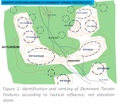
Each candidate feature is examined in relation to the mission, enemy capabilities, friendly concept of operations, likely avenues of approach, obstacles, weather, vegetation, and the availability of aerial observation. Features are then ranked by tactical effect. Tier 1 dominantterrain features are those whose use or denial can decisively shape the operation. Tier 2 features enable access to, support, observe, or threaten Tier 1 features. Lower-tier features may serve as entry points, staging areas, concealed approaches, firing positions, sensor locations, or displacement routes.

The rank is relational rather than permanent. A feature may be Tier 1 for one mission and Tier 2 for another.

The commander should therefore avoid treating terrain classification as a static cartographic product. Ranking must reflect the operational problem, the adversary’s likely scheme of maneuver, and the effects required by the friendly force.

The output of Step 1 is a terrain hierarchy that distinguishes geographical prominence from operational relevance. This prevents a common planning error: committing combat power to the highest features simply because they dominate the map. Instead, the staff identifies which features truly determine access, observation, fires, and freedom of action.

Step 2: Analyze Tactical Interdependencies

The second step examines how the identified features influence one another. Mountain terrain functions as a system. A ridge may control a valley, but access to that ridge may depend on a saddle. A summit may provide observation, but its sustainment may depend on a concealed route overlooked by a lower spur. Tactical value therefore emerges from relationships, not from isolated features (Department of the Army 2016, 2019).
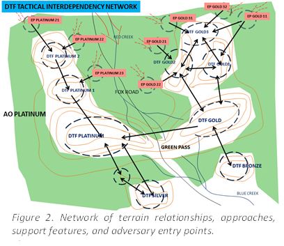
Tactical interdependency is the mutual influence between terrain features connected by a direction of action, observation, support, or access. The analysis begins with Tier 1 features and works outward. For each feature, the staff asks which adjacent features enable its capture, support its defense, provide observation into it, block reinforcement, or permit bypass. The analysis continues until it reaches lower-tier entry points through which the adversary can enter the defensive system.

This step should identify primary and alternate approaches, mandatory routes, dead ground, likely UAS launch and recovery areas, firing positions, reserve routes, logistics corridors, and potential landing zones. It should also identify dependencies that create vulnerability. If a Tier 1 position depends on a single exposed route, that route may be more important to defend than the position itself (Department of the Army 2019; Klein 1998).

The output is a tactical interdependency network. This network reveals where the adversary must pass, what must be observed, which lower-tier features can generate leverage over higher-tier terrain, and where limited friendly resources can create disproportionate effects.

Step 3: Assess Defensive Capability Requirements

The third step converts terrain value into capability requirements. For every significant feature, the staff determines what is required to occupy it, control it indirectly, observe it, deny it, or recover it. The analysis includes maneuver forces, fires, ISR, counter-UAS, engineering, communications, medical support, sustainment, and reserves.
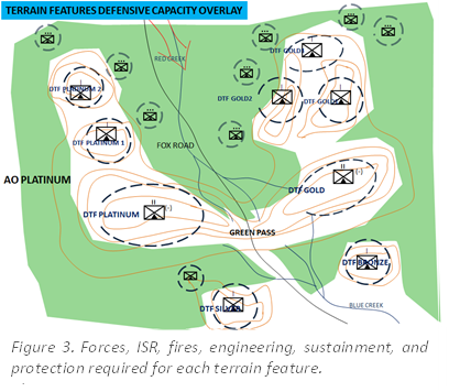
This is not a simple force-to-space calculation. A feature with high tactical value may be unsuitable for continuous occupation if it cannot be concealed, resupplied, reinforced, or evacuated. Conversely, a lower-tier feature may offer a better combination of protection, access, fields of fire, and sensor coverage. The staff must therefore compare tactical benefit with exposure and supportability.

Requirements should be developed for primary, alternate, and supplementary positions. Occupation time, displacement triggers, route capacity, communications redundancy, ammunition expenditure, casualty evacuation, and the ability to operate under electronic attack should be considered (Department of the Army 2019). Friendly UAS can reduce the need for exposed observation posts, while obstacles and preplanned fires can reduce the number of troops required to deny an approach.

The output is a defensive capability overlay that shows where direct occupation is sustainable, where intermittent occupation is possible, and where indirect control is preferable. It also exposes mismatches between what terrain demands and what the force can provide. Those mismatches are essential planning information, not merely resource shortages.

Step 4: Build the Integrated Terrain Control Overlay

The fourth step overlays the terrain hierarchy, tactical interdependencies, and capability requirements into a single operational picture. This is where separate analytical products become a defensive concept. The staff can now see which features are decisive, how they are connected, what resources they require, and where the adversary is most likely to encounter friction.
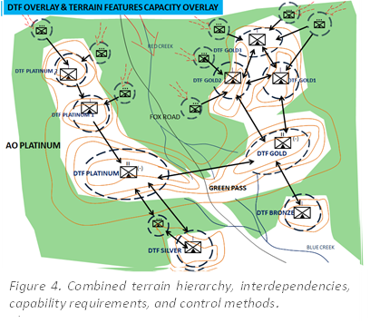
The overlay should identify control zones, engagement areas, observation sectors, unmanned-system employment areas, obstacle belts, routes for displacement and counterattack, false positions, and locations where signatures must be minimized. It should also expose unnecessary duplication, uncovered approaches, single points of failure, and positions whose resource costs exceed their operational contribution.

The commander can then compare alternative control methods. One option may place a strong force on a Tier 1 ridge. Another may use concealed Tier 2 positions, remote sensors, fires, and a mobile reserve to deny the same ridge. The comparison should consider survivability, responsiveness, sustainability, and the degree of uncertainty imposed on the adversary (Department of the Army 2016, 2023).

The output is an integrated terrain control overlay that supports course-of-action development and wargaming. Its value lies in making the defense understandable as a system of effects rather than a collection of occupied points.

Step 5: Prioritize and Group Objectives by Required Effect

The fifth step groups terrain features into operational objectives and assigns a required control effect to each objective. The commander determines which features must be held, which must be denied, which must be observed, which may be temporarily ceded, and which should be used primarily for deception (Department of the Army 2016). This translates analysis into tasks and priorities.
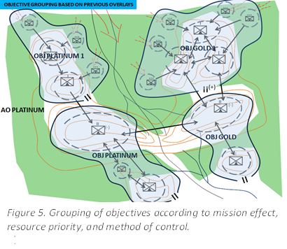
Primary objectives are linked to Tier 1 effects and the stability of the defensive sector. Secondary objectives support, enable, or protect the primary objectives. Supporting objectives control entry points, routes, sensor positions, engagement areas, or sustainment functions. The grouping should align command relationships, fires, ISR, mobility support, and logistics with the effect required at each objective.

The decisive innovation is that the highest-ranked terrain does not automatically receive the largest permanent force. Where feasible, lower-rank features are occupied to generate control effects over higher-rank terrain. False positions may be prepared on exposed dominant features, while real combat power remains concealed on supporting terrain. The defender can then observe, channel, disrupt, and strike an adversary attempting to exploit the apparent gap.

The output is an objective-based defense plan in which force presence is selective, signatures are managed, and terrain is controlled through a combination of occupation, denial, surveillance, fires, deception, and maneuver.

Illustrative Operational Application of MW-TDS-5

Consider a defensive sector organized around a pass and two Tier 1 dominant terrain features that overlook the principal approaches. A conventional scheme would place substantial forces directly on both dominant features (Department of the Army 2024). Under persistent ISR, however, the positions, access routes, and sustainment activity would become increasingly observable. The defender could gain early observation yet lose survivability and freedom of action.
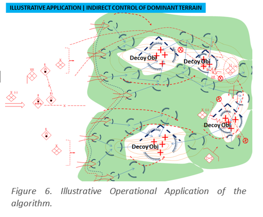
Using MW-TDS-5, the staff first ranks the dominant features and the lower terrain controlling access to them. It then maps the interdependencies linking the pass, saddles, spurs, valley routes, entry points, and likely enemy support positions. Capability assessment shows that continuous occupation of the Tier 1 features would require disproportionate force protection and sustainment. The integrated overlay instead identifies concealed Tier 2 features from which sensors, fires, obstacles, and maneuver elements can influence the Tier 1 terrain.

The final plan prepares the exposed Tier 1 features as simulated defensive positions and observes them continuously. Friendly forces occupy selected lower-rank terrain, control access routes, maintain mobile reserves, and prearrange fires on likely enemy assembly and exploitation areas. When the adversary commits against the apparent positions or attempts to use the dominant terrain, the defender creates a control effect through detection, channelization, isolation, and engagement.

The operational advantage is not merely reduced exposure. The scheme also interferes with adversary decision-making. The adversary is encouraged to allocate ISR and fires against false or temporary signatures, while the real defensive system remains distributed (Department of the Army 2023; Joint Chiefs of Staff 2022). The defender retains the ability to concentrate combat power at decisive moments without revealing the complete disposition in advance.

The Final Effect: Control Without Predictable Exposure

The final effect of MW-TDS-5 is the creation of a resilient terrain-control system that denies the adversary freedom of action while minimizing predictable friendly exposure. The framework does not seek to abandon dominant terrain. It seeks to separate its operational value from the assumption that value can only be realized through permanent occupation.

When correctly applied, the algorithm produces five mutually reinforcing outcomes. First, it concentrates analysis on tactically decisive terrain rather than topographic prominence. Second, it reveals the lower-rank features and routes that enable control of decisive terrain. Third, it aligns defensive resources with actual mission requirements and sustainment realities. Fourth, it integrates terrain, ISR, fires, obstacles, deception, and maneuver into a coherent control architecture. Fifth, it converts this architecture into prioritized objectives defined by required effect.

The result is a defense that remains influential without becoming fixed, visible, and easily targetable. The adversary faces uncertainty about where combat power is located, which positions are real, which routes are covered, and when the defender will concentrate. This uncertainty imposes time, increases reconnaissance requirements, complicates targeting, and creates opportunities for counteraction.

At the operational level, MW-TDS-5 preserves the enduring value of mountain terrain while adapting its use to a transparent battlespace. At the tactical level, it provides commanders with a disciplined method for deciding where to occupy, where to observe, where to deceive, where to deny, and where to remain mobile. Its essential proposition is simple: control is measured by the adversary’s inability to use terrain effectively, not by the defender’s continuous physical presence on every dominant feature.

Implications for NATO Mountain Forces

Doctrine: Mountain warfare doctrine should distinguish explicitly among occupation, denial, observation, and indirect control. Terrain tasks should be defined by required effect rather than by presence alone (Department of the Army 2023).

Training: Command-post exercises should require staffs to rank terrain, map interdependencies, compare direct and indirect control options, and rehearse displacement under persistent observation (NATO Allied Command Transformation 2021).

Force Structure: Mountain formations require mobile command posts, distributed sensors, counter-UAS capabilities, precision fires, engineers, and sustainment systems able to support dispersed objective-based defense (NATO Mountain Warfare Centre of Excellence 2023; NATO Standardization Office 2020).

Deception: Deception and signature management should be incorporated from the beginning of planning. False positions and controlled activity patterns must be linked to the expected adversary collection and targeting process (Blatny and Søndergaard 2025; McDermott 2017).

UAS Integration: Friendly UAS should extend observation, support route surveillance, confirm control effects, and reduce the need to expose larger forces on dominant terrain.

Command and Control: Mission command is essential. Dispersed forces require clear intent, decision thresholds, delegated authorities, and rehearsed criteria for displacement, concentration, and recovery of terrain (Joint Chiefs of Staff 2022; U.S. Army Training and Doctrine Command 2018).

Conclusion

Contemporary conflict does not make dominant terrain irrelevant. It changes the way dominant terrain must be controlled. Persistent ISR, unmanned strike systems, and accelerated sensor-to-shooter cycles reduce the survivability of forces that equate tactical value with continuous occupation. In mountainous terrain, where routes and positions are constrained, this risk is amplified.

Indirect terrain control offers a practical response. By combining mobility, dispersion, deception, ISR, fires, obstacles, and selective occupation, mountain forces can deny adversary use of decisive terrain without presenting a predictable target. The MW-TDS-5 framework provides a structured method for translating that concept into planning outputs and tactical tasks.

The central doctrinal lesson is that altitude no longer guarantees control, and presence no longer proves dominance. The decisive measure is effect: whether the adversary can observe, maneuver, sustain, and fight from the terrain. A force that controls these functions may dominate a feature without continuously occupying it. This shift from terrain occupation to terrain influence is the final effect of MW-TDS-5 and its principal contribution to the adaptation of mountain warfare.

“The views and opinions expressed in this article are those of the author and do not necessarily reflect the official position of the NATO Mountain Warfare Centre of Excellence, NATO, or its member and contributing nations. The article is published as a professional contribution from a representative of one of the Centre’s Contributing Nations, with the aim of encouraging discussion and the exchange of ideas on emerging challenges and developments in Mountain Warfare.”

References

  • Bailey, Riley, Kateryna Stepanenko, Angelica Evans, Nicole Wolkov, Nate Trotter, and Frederick W. Kagan. 2024. “Russian Offensive Campaign Assessment, October 16, 2024.” Institute for the Study of War, October 16, 2024. Accessed January 19, 2026. https://understandingwar.org/research/russia-ukraine/russian-offensive-campaign-assessment_16/.

  • Blatny, Janet M., and Steen Søndergaard. 2025. Cognitive Warfare. NATO Chief Scientist Research Report STO-OCS-001. Brussels: NATO Science and Technology Organization. Accessed June 18, 2026. https://www.sto.nato.int/document/cognitive-warfare/.

  • Department of the Army. 2000. FM 3-97.6, Mountain Operations. Washington, DC: Headquarters, Department of the Army.

  • Department of the Army. 2016. ATP 3-90.97, Mountain Warfare and Cold Weather Operations. Washington, DC: Headquarters, Department of the Army.

  • Department of the Army. 2019. ATP 2-01.3, Intelligence Preparation of the Battlefield. Washington, DC: Headquarters, Department of the Army.

  • Department of the Army. 2023. FM 3-90, Tactics. Washington, DC: Headquarters, Department of the Army.

  • Department of the Army. 2024. FM 5-0, Planning and Orders Production. Washington, DC: Headquarters, Department of the Army.

  • Harrison, Todd. 2021. Battle Networks and the Future Force, Part 1: A Framework for Debate. Washington, DC: Center for Strategic and International Studies. Accessed January 12, 2026. https://www.csis.org/analysis/battle-networks-and-future-force.

  • Joint Chiefs of Staff. 2022. Joint Publication 3-0, Joint Campaigns and Operations. Washington, DC: Joint Chiefs of Staff. Accessed February 5, 2026. https://www.jcs.mil/Doctrine/Joint-Doctrine-Pubs/3-0-Operations-Series/.

  • Klein, Gary. 1998. Sources of Power: How People Make Decisions. Cambridge, MA: MIT Press. Accessed January 26, 2026. https://mitpress.mit.edu/9780262611466/sources-of-power/.

  • Kuhar, Miha. 2023. “Vertical Manoeuvre Link with MW Concept 0.9.” In 5th Congress Book. Begunje na Gorenjskem, Slovenia: NATO Mountain Warfare Centre of Excellence. Accessed February 12, 2026. https://www.mwcoe.org/docs/5th-congress-book/05-vertical-manoeuvre-link-with-mw-concept-0-9/.

  • Luckey, David, Bradley M. Knopp, Sasha Romanosky, Amanda Wicker, David Stebbins, Cortney Weinbaum, Sunny D. Bhatt, Hilary Reininger, Yousuf Abdelfatah, and Sarah Heintz. 2021. Measuring Intelligence, Surveillance, and Reconnaissance Effectiveness at the United States Central Command. Research Report RR-4360-OSD. Santa Monica, CA: RAND Corporation. Accessed January 15, 2026. https://www.rand.org/pubs/research_reports/RR4360.html

  • McDermott, Roger N. 2017. Russia’s Electronic Warfare Capabilities to 2025: Challenging NATO in the Electromagnetic Spectrum. Tallinn: International Centre for Defence and Security. Accessed January 22, 2026. https://icds.ee/en/russias-electronic-warfare-capabilities-to-2025-challenging-nato-in-the-electromagnetic-spectrum/.

  • NATO Allied Command Transformation. 2021. NATO Warfighting Capstone Concept. Norfolk, VA: Allied Command Transformation. Accessed February 2, 2026. https://www.act.nato.int/our-work/nato-warfighting-capstone-concept/.

  • NATO Mountain Warfare Centre of Excellence. 2023. 5th Congress Book. Begunje na Gorenjskem, Slovenia: NATO Mountain Warfare Centre of Excellence. Accessed February 15, 2026. https://www.mwcoe.org/doc/5th-congress-book/.

  • NATO Standardization Office. 2020. ATrainP-6, Mountain Warfare Education and Training. Edition A, Version 1. Brussels: NATO Standardization Office.

  • Nistorescu, Claudiu Valer. 2024. “Adaptarea organizației militare – o condiție esențială pentru obținerea succesului pe câmpul de luptă.” Gândirea Militară Românească 3 (2024). https://doi.org/10.55535/GMR.2024.3.10.

  • Seip, Mark. 2020. “Bad Idea: All Sensors, All Shooters, All the Time: A Joint All-Domain Command and Control System That Prioritizes Centralization.” Defense360. Center for Strategic and International Studies, December 15, 2020. https://defense360.csis.org/bad-idea-all-sensors-all-shooters-all-the-time-a-joint-all-domain-command-and-control-system-that-prioritizes-centralization/.

  • Stanciu, Cristian-Octavian, și Silviu-Iulian Gimiga. 2023. „Noile tehnologii și impactul lor asupra domeniului militar.” Buletinul Universității Naționale de Apărare „Carol I” 12 (2): 157–169. https://doi.org/10.53477/2284-9378-23-27.

  • U.S. Army Training and Doctrine Command. 2018. TRADOC Pamphlet 525-3-1, The U.S. Army in Multi-Domain Operations 2028. Fort Eustis, VA: U.S. Army Training and Doctrine Command. Accessed February 7, 2026.  https://www.army.mil/article/243754/the_u_s_army_in_multi_domain_operations_2028

Share this post

Loading...